Shapefile (Vector) Handling#
This section introduces geospatial analysis of shapefiles with gdal, ogr, and osr. For interactive reading and executing code blocks ![]() and find geo01-shp.ipynb, or install Python and JupyterLab locally.
and find geo01-shp.ipynb, or install Python and JupyterLab locally.
Requirements
Make sure to understand shapefiles and vector data
Accomplish the QGIS tutorial
Use flusstools
The core functions featured in this section are also implemented in flusstools. To use those functions, make sure flusstools is installed and import it as follows: from flusstools import geotools. Some of the functions shown in this tutorial can then be used with geotools.function_name().
Watch this section and the Python tutorials in video formats
Watch this section as a video on the @Hydro-Morphodynamics channel on YouTube.
Load an Existing Shapefile#
OSGeo’s ogr module is an excellent source for handling shapefiles. After importing the libraries, the correct driver for handling shapefiles ("ESRI Shapefile") with Python needs to be called. Next, with the driver object (ogr.GetDriverByName("SHAPEFILE")), we can open (instantiate) a shapefile (object with shp_driver.Open("SHAPEFILE")), which contains layer information. It is precisely the layer information (i.e., references to shapefile attributes) that we want to work with. Therefore we have to instantiate a shapefile layer object with shp_dataset.GetLayer().
from osgeo import ogr
shp_driver = ogr.GetDriverByName("ESRI Shapefile")
shp_dataset = shp_driver.Open("geodata/shapefiles/cities.shp")
shp_layer = shp_dataset.GetLayer()
Tip
To get a full list of supported ogr drivers (e.g., for DXF, ESRIJSON, GPS, PDF, SQLite, XLSX, and many more), download the script get_ogr_drivers.py from hydro-informatics on Github.
Do not use from gdal import ogr
Importing ogr with from gdal import ogr is deprecated since GDAL v3. Therefore, ogr must be imported from osgeo.
Create a New Shapefile#
ogr also enables creating a new point, line, or polygon shapefile. The following code block defines a function for creating a shapefile, where the optional keyword argument overwrite is used to control whether an existing shapefile with the same name should be overwritten (default: True).
The command shp_driver.CreateDataSource(SHP-FILE-DIR) creates a new shapefile and the rest of the function adds a layer to the shapefile if the optional keyword arguments layer_name and layer_type are provided. Both optional keywords must be strings, where layer_name can be any name for the new layer. layer_type must be either "point", "line", or "polygon" to create a point, (poly)line, or polygon shapefile, respectively. The function uses the geometry_dict dictionary to assign the correct ogr.SHP-TYPE to the layer. There are more options for extending the create_shp(...) function listed on pcjerick’s Github pages.
from osgeo import ogr
import os


def create_shp(shp_file_dir, overwrite=True, *args, **kwargs):
    """
    :param shp_file_dir: STR of the (relative shapefile directory (ends on ".shp")
    :param overwrite: [optional] BOOL - if True, existing files are overwritten
    :kwarg layer_name: [optional] STR of the layer_name - if None: no layer will be created (max. 13 chars)
    :kwarg layer_type: [optional] STR ("point, "line", or "polygon") of the layer_name - if None: no layer will be created
    :output: returns an ogr shapefile layer
    """
    shp_driver = ogr.GetDriverByName("ESRI Shapefile")

    # check if output file exists if yes delete it
    if os.path.exists(shp_file_dir) and overwrite:
        shp_driver.DeleteDataSource(shp_file_dir)

    # create and return new shapefile object
    new_shp = shp_driver.CreateDataSource(shp_file_dir)

    # create layer if layer_name and layer_type are provided
    if kwargs.get("layer_name") and kwargs.get("layer_type"):
        # create dictionary of ogr.SHP-TYPES
        geometry_dict = {"point": ogr.wkbPoint,
                         "line": ogr.wkbMultiLineString,
                         "polygon": ogr.wkbMultiPolygon}
        # create layer
        try:
            new_shp.CreateLayer(str(kwargs.get("layer_name")),
                                geom_type=geometry_dict[str(kwargs.get("layer_type").lower())])
        except KeyError:
            print("Error: Invalid layer_type provided (must be 'point', 'line', or 'polygon').")
        except TypeError:
            print("Error: layer_name and layer_type must be string.")
        except AttributeError:
            print("Error: Cannot access layer - opened in other program?")
    return new_shp
The create_shp function is also provided with flusstools (flusstools.geotools.create_shp()) and aids to create a new shapefile (make sure to get the directory right):
a_new_shp_file = create_shp(r"" + os.getcwd() + "/geodata/shapefiles/new_polygons.shp", layer_name="basemap", layer_type="polygon")

# release data source
a_new_shape_file = None
Important
A shapefile name may not have more than 13 characters and a field name may not have more than 10 characters (read more in Esri’s shapefile docs).
Shapefiles can also be created and drawn in QGIS and the following figures guide through the procedure of creating a polygon shapefile. We will not need the resulting shapefile in this section anymore, but later for making it interact with raster datasets.
The first step to making a shapefile with QGIS is obviously to run QGIS and create a new project. The following example uses water depth and flow velocity raster data as background information to delineate the so-called morphological unit of slackwater. Both the water depth and flow velocity rasters are part of the River Architect sample datasets (precisely located at RiverArchitect/SampleData/01_Conditions/2100_sample/). After downloading the sample data, they can be imported in QGIS by dragging the files from the Browser panel into the Layers panel. Then:
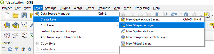
Fig. 43 QGIS: Create Layer > New Shapefile Layer…#
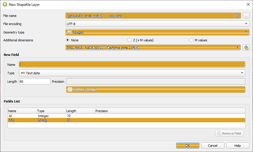
Fig. 44 Define New Shapefile Layer#
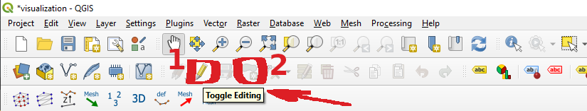
Fig. 45 Enable shapefile editing#
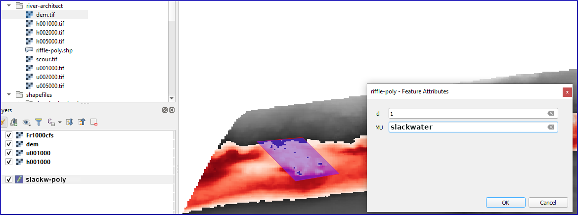
Fig. 46 Draw polygons in a shapefile in QGIS.#
Get and Set Shapefile Projections#
The terminology used in the .prj files of a shapefile corresponds to the definitions in the geospatial data section. In Python, information about the coordinate system is available through shp_layer.GetSpatialRef() of the ogr library:
shp_srs = shp_layer.GetSpatialRef()
print(shp_srs)
GEOGCS["WGS 84",
    DATUM["WGS_1984",
        SPHEROID["WGS 84",6378137,298.257223563,
            AUTHORITY["EPSG","7030"]],
        AUTHORITY["EPSG","6326"]],
    PRIMEM["Greenwich",0,
        AUTHORITY["EPSG","8901"]],
    UNIT["degree",0.0174532925199433,
        AUTHORITY["EPSG","9122"]],
    AXIS["Latitude",NORTH],
    AXIS["Longitude",EAST],
    AUTHORITY["EPSG","4326"]]
This GEOGCS definition of the above shapefile corresponds to Esri’s well-known text (WKT). Since the shapefile format was developed by Esri, Esri’s WKT (esriwkt) format must be used in .prj files. The Open Geospatial Consortium (OGC) uses a different well-known text in their EPSG:XXXX definitions (e.g., available at spatialreference.org).
GEOGCS["WGS 84",
       DATUM["WGS_1984", SPHEROID["WGS84", 6378137, 298.257223563, AUTHORITY["EPSG", "7030"]], AUTHORITY["EPSG","6326"]],
       PRIMEM["Greenwich", 0, AUTHORITY["EPSG", "8901"]],
       UNIT["degree",0.01745329251994328, AUTHORITY["EPSG","9122"]],AUTHORITY["EPSG","4326"]]
To redefine or newly define the coordinate system of a shapefile, we can use spatialreference.org through Python’s default urllib library.
Note
Running the following code block requires an internet connection.
import urllib

# function to get spatialreferences with epsg code
def get_esriwkt(epsg):
    # usage get_epsg_code(4326)
    try:
        with urllib.request.urlopen("http://spatialreference.org/ref/epsg/{0}/esriwkt/".format(epsg)) as response:
            return str(response.read()).strip("b").strip("'")
    except Exception:
        pass
    try:
        with urllib.request.urlopen("http://spatialreference.org/ref/sr-org/epsg{0}-wgs84-web-mercator-auxiliary-sphere/esriwkt/".format(epsg)) as response:
            return str(response.read()).strip("b").strip("'")
        # sr-org codes are available at "https://spatialreference.org/ref/sr-org/{0}/esriwkt/".format(epsg)
        # for example EPSG:3857 = SR-ORG:6864 -> https://spatialreference.org/ref/sr-org/6864/esriwkt/ = EPSG:3857
    except Exception:
        print("ERROR: Could not find epsg code on spatialreference.org. Returning default WKT(epsg=4326).")
        return 'GEOGCS["GCS_WGS_1984",DATUM["D_WGS_1984",SPHEROID["WGS_1984",6378137,298.257223563]],PRIMEM["Greenwich",0],UNIT["Degree",0.017453292519943295],UNIT["Meter",1]]'
This function can be used to create a new projection file:
# open the hypy-area shapefile
shp_file = "hypy-area"

# create new .prj file for the shapefile (.shp and .prj must have the same name)
with open("geodata/shapefiles/{0}.prj".format(shp_file), "w") as prj:
    epsg_code = get_esriwkt(4326)
    prj.write(epsg_code)
    print("Wrote projection file : " + epsg_code)
Wrote projection file : GEOGCS["GCS_WGS_1984",DATUM["D_WGS_1984",SPHEROID["WGS_1984",6378137,298.257223563]],PRIMEM["Greenwich",0],UNIT["Degree",0.017453292519943295]]
An offline alternative for generating a .prj file is the osr library that comes along with gdal:
from osgeo import osr

def get_wkt(epsg, wkt_format="esriwkt"):
    default = 'GEOGCS["GCS_WGS_1984",DATUM["D_WGS_1984",SPHEROID["WGS_1984",6378137,298.257223563]],PRIMEM["Greenwich",0],UNIT["Degree",0.017453292519943295],UNIT["Meter",1]]'
    spatial_ref = osr.SpatialReference()
    try:
        spatial_ref.ImportFromEPSG(epsg)
    except TypeError:
        print("ERROR: epsg must be integer. Returning default WKT(epsg=4326).")
        return default
    except Exception:
        print("ERROR: epsg number does not exist. Returning default WKT(epsg=4326).")
        return default
    if wkt_format=="esriwkt":
        spatial_ref.MorphToESRI()
    # return a nicely formatted WKT string (alternatives: ExportToPCI(), ExportToUSGS(), or ExportToXML())
    return spatial_ref.ExportToPrettyWkt()
Transform (Re-project) a Shapefile#
A re-projection may be needed, for instance, to use a shapefile in EPSG:4326 (e.g., created with QGIS) in a web-GIS application (e.g., open street maps) that typically uses EPSG:3857. To apply a different projection to geometric objects of a shapefile, it is not enough to simply rewrite the .prj file. Therefore, the following example shows the re-projection of the countries.shp shapefile from the Natural Earth quick start kit. The following workflow performs the reprojection:
Save shapefile to transform is located in the subdirectory
geodata/shapefiles/countries.shpand open it in the Python script as described above.Read and identify the spatial reference system used in the input shapefile:
Create a spatial reference object with
in_sr = osr.SpatialReference(str(shapefile.GetSpatialRef())).Detect the spatial reference system in EPSG format with
AutoIdentifyEPSG().Assign the EPSG-formatted spatial reference system to the spatial reference object of the input shapefile (
ImportFromEPSG(int(in_sr.GetAuthorityCode(None)))).
Create the output spatial reference with
out_sr = osr.SpatialReference()and apply the target EPSG code (out_sr.ImportFromEPSG(3857)).Create a coordinate transformation object (
coord_trans = osr.CoordinateTransformation(in_sr, out_sr)) that enables re-projecting geometry objects later.Create the output shapefile, which will correspond to a copy of the input shapefile (use the above-defined
create_shpfunction withlayer_name="basemap"andlayer_type="line").Copy the field names and types of the input shapefile:
Read the attribute layer from the input file’s layer definitions with
in_lyr_def = in_shp_lyr.GetLayerDefn()Iterate through the field definitions and append them to the output shapefile layer (
out_shp_lyr)
Iterate through the geometry features in the input shapefile:
Use the new (output) shapefile’s layer definitions (
out_shp_lyr_def = out_shp_lyr.GetLayerDefn()) to append transformed geometry objects later.Define an iteration variable
in_featureas an instance ofin_shp_lyr.GetNextFeature.In a
whileloop, instantiate every geometry (geometry = in_feature.GetGeometryRef()) in the input shapefile, transform thegeometry(geometry.Transform(coord_trans)), convert it to anogr.Feature()with theSetGeometry(geometry)method, copy field definitions (nestedfor-loop), and append the new feature to the output shapefile layer (out_shp_lyr_def.CreateFeature(out_feature)).At the end of the
while-loop, look for the next feature in the input shapefile’s attributes within_feature = in_shp_lyr.GetNextFeature()
Unlock (release) all layers and shapefiles by overwriting the objects with
None(nothing is written to any file as long as these variables exist!).Assign the new projection EPSG:3857 using the above-defined
get_wktfunction.
from osgeo import ogr
from osgeo import osr

shp_driver = ogr.GetDriverByName("ESRI Shapefile")

# open input shapefile and layer
in_shp = shp_driver.Open(r"" + os.path.abspath("") + "/geodata/shapefiles/countries.shp")
in_shp_lyr = in_shp.GetLayer()

# get input SpatialReference
in_sr = osr.SpatialReference(str(in_shp_lyr.GetSpatialRef()))
# auto-detect epsg
in_sr.AutoIdentifyEPSG()
# assign input SpatialReference
in_sr.ImportFromEPSG(int(in_sr.GetAuthorityCode(None)))

# create SpatialReference for new shapefile
out_sr = osr.SpatialReference()
out_sr.ImportFromEPSG(3857)

# create a CoordinateTransformation object
coord_trans = osr.CoordinateTransformation(in_sr, out_sr)

# create output shapefile and get layer
out_shp = create_shp(r"" + os.path.abspath("") + "/geodata/shapefiles/countries-web.shp", layer_name="basemap", layer_type="line")
out_shp_lyr = out_shp.GetLayer()

# look up layer (features) definitions in input shapefile
in_lyr_def = in_shp_lyr.GetLayerDefn()
# copy field names of input layer attribute table to output layer
for i in range(0, in_lyr_def.GetFieldCount()):
    out_shp_lyr.CreateField(in_lyr_def.GetFieldDefn(i))

# instantiate feature definitions object for output layer (currently empty)
out_shp_lyr_def = out_shp_lyr.GetLayerDefn()

# iteratively append all input features in new projection
in_feature = in_shp_lyr.GetNextFeature()
while in_feature:
    # get the input geometry
    geometry = in_feature.GetGeometryRef()
    # re-project (transform) geometry to new system
    geometry.Transform(coord_trans)
    # create new output feature
    out_feature = ogr.Feature(out_shp_lyr_def)
    # assign in-geometry to output feature and copy field values
    out_feature.SetGeometry(geometry)
    for i in range(0, out_shp_lyr_def.GetFieldCount()):
        out_feature.SetField(out_shp_lyr_def.GetFieldDefn(i).GetNameRef(), in_feature.GetField(i))
    # add the feature to the shapefile
    out_shp_lyr.CreateFeature(out_feature)
    # prepare next iteration
    in_feature = in_shp_lyr.GetNextFeature()

# release shapefiles and layers
in_shp = None
in_shp_lyr = None
out_shp = None
out_shp_lyr = None

# create .prj file for  output shapefile for web application references
with open(r"" + os.path.abspath('') + "/geodata/shapefiles/countries-web.prj", "w+") as prj:
    prj.write(get_wkt(3857))
Challenge
Re-write the above code block in a re_project(shp_file, target_epsg) function.
In the case of success, the code sequence in_sr.AutoIdentifyEPSG() returns 0 (i.e., it successfully recognized the EPSG number), but unfortunately, many EPSG numbers are not known to AutoIdentifyEPSG(). In the case that AutoIdentifyEPSG() did not function propperly, the method does not return 0, but 7, for example. A workaround for the limited functionality of srs.AutoIdentifyEPSG() is srs.FindMatches. srs.FindMatches returns a matching srs_match from a larger database, which is somewhat nested; for instance, use:
matches = srs.FindMatches()
Then, matches looks like this: [(osgeo.osr.SpatialReference, INT)]. Therefore, a complete workaround for srs.AutoIdentifyEPSG() (or in_sr.AutoIdentifyEPSG() in the code block above) looks like this:
# set epsg and create spatial reference object
epsg = 3857
srs = osr.SpatialReference()
srs.ImportFromEPSG(epsg)

# identify spatial reference
auto_detect = srs.AutoIdentifyEPSG()
if auto_detect is not 0:
    srs = srs.FindMatches()[0][0]  # Find matches returns list of tuple of SpatialReferences
    srs.AutoIdentifyEPSG()  # Re-perform auto-identification
Add Fields and Point Features to a Shapefile#
A shapefile feature can be a point, a line, or a polygon, which has field attributes (e.g., "id"=1 to describe that this is polygon number 1 or associated to an id block 1). Field attributes can be more than just an IDentifier and include, for example, the polygon area or city labels as in the above-shown example illustrating cities.shp (shp_driver.Open("geodata/shapefiles/cities.shp")).
To create a point shapefile, we can use the above-introduced create_shp function (or flusstools.geotools.create_shp(shp_file_dir="")) and set the projection with the get_wkt() function (also above introduced). The following code block shows the usage of both functions to create a river.shp point shapefile that contains three points located at three rivers in central Europe. The code block also illustrates the creation of a field in the attribute table and the creation of three point features. Here is how the code works:
The shapefile is located in the
rivers_ptsvariable. Note that thelayer_typealready determines the type of geometries that can be used in the shapefile. For instance, adding a line or polygon feature to anogr.wkbPointlayer will result in anERROR 1message.The
basemap(layer) is attributed to the variablelyr = river_pts.GetLayer().A string-type field is added and appended to the attribute table:
instantiate a new field with
field_gname = ogr.FieldDefn("FIELD-NAME", ogr.OFTString)(recall: the field name may not have more than 10 characters!)append the new field to the shapefile with
lyr.CreateField(field_gname)other field types than
OFTStringcan be:OFTInteger,OFTReal,OFTDate,OFTTime,OFTDateTime,OFTBinary,OFTIntegerList,OFTRealList, orOFTStringList.
Add three points stored in
pt_names = {RIVER-NAME: (x-coordinate, y-coordinate)}in a loop over the dictionary keys:for every new point, create a feature as a child of the layer defintions with
feature = ogr.Feature(lyr.GetLayerDefn())set the value of the field name for every point with
feature.SetField(FIELD-NAME, FIELD-VALUE)create a string of the new point in WKT format with
wkt = "POINT(X-COORDINATE Y-COORDINATE)"convert the WKT-formatted point into a point-type geometry with
point = ogr.CreateGeometryFromWkt(wkt)set the new point as the new feature’s geometry with
feature.SetGeometry(point)append the new feature to the layer with
lyr.CreateFeature(feature)
Unlock (release) the shapefile by overwriting the
lyrandriver_ptsvariable withNone.
Important
The operations are not written to the shapefile if the lyr and river_pts objects are not overwritten with None.
shp_dir = r"" + os.path.abspath('') + "/geodata/shapefiles/rivers.shp"
river_pts = create_shp(shp_dir, layer_name="basemap", layer_type="point")

# create .prj file for the shapefile for web application references
with open(shp_dir.split(".shp")[0] + ".prj", "w+") as prj:
    prj.write(get_wkt(3857))

# get basemap layer
lyr = river_pts.GetLayer()

# add string field "rivername"
field_gname = ogr.FieldDefn("rivername", ogr.OFTString)
lyr.CreateField(field_gname)

# names and coordinates of central EU rivers in EPSG:3857 WG84 / Pseudo-Mercator
pt_names = {"Aare": (916136.03, 6038687.72),
            "Ain": (623554.12, 5829154.69),
            "Inn": (1494878.95, 6183793.83)}

# add the three rivers as points to the basemap layer
for n in pt_names.keys():
    # create Feature as child of the layer
    pt_feature = ogr.Feature(lyr.GetLayerDefn())
    # define value n (river) in the rivername field
    pt_feature.SetField("rivername", n)
    # use WKT format to add a point geometry to the Feature
    wkt = "POINT(%f %f)" % (float(pt_names[n][0]), float(pt_names[n][1]))
    point = ogr.CreateGeometryFromWkt(wkt)
    pt_feature.SetGeometry(point)
    # append the new feature to the basement layer
    lyr.CreateFeature(pt_feature)

# release files
lyr = None
river_pts = None
The resulting rivers.shp shapefile can be imported in QGIS along with a DEM from the Natural Earth quick start kit.
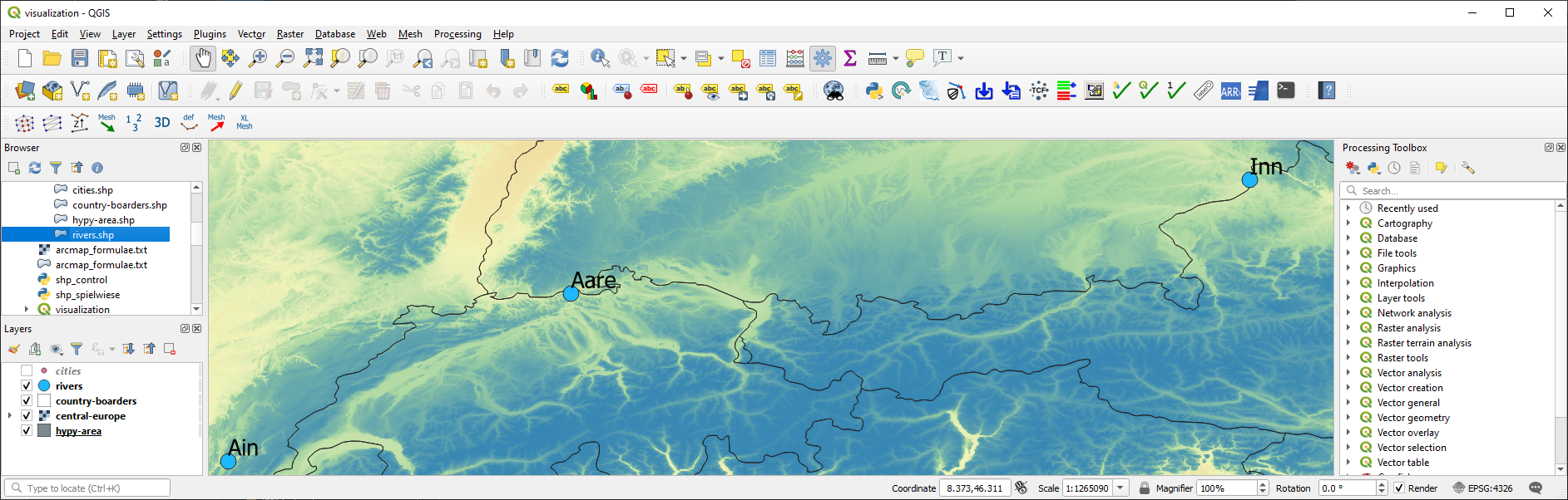
Fig. 47 The river names bound to points in a point shapefile shown in QGIS.#
Multiline (Polyline) Shapefile#
Similar to the procedure for creating and adding points to a new point shapefile, a (multi) line (or polyline) can be added to a shapefile. The create_shp function creates a multi-line shapefile when the layer type is defined as "line" (flusstools.geotools.create_shp(shp_file_dir="", layer_type="line")). The coordinate system is created with the above-defined get_wkt() function.
Tip
The term multi-line is used in OGC and ogr, while polyline is used in Esri GIS environments.
The following code block uses the coordinates of cities along the Rhine River, stored in a dictionary named station_names. The city names are not used and only the coordinates are appended with line.AddPoint(X, Y). As before, a field is created to give the river a name. The actual line feature is again created as a child of the layer with line_feature = ogr.Feature(lyr.GetLayerDefn()). Running this code block produces a line that approximately follows the Rhine River between France and Germany.
shp_dir = r"" + os.path.abspath("") + "/geodata/shapefiles/rhine_proxy.shp"
rhine_line = create_shp(shp_dir, layer_name="basemap", layer_type="line")

# create .prj file for the shapefile for web application references
with open(shp_dir.split(".shp")[0] + ".prj", "w+") as prj:
    prj.write(get_wkt(3857))

# get basemap layer
lyr = rhine_line.GetLayer()

# coordinates for EPSG:3857 WG84 / Pseudo-Mercator
station_names = {"Basel": (844361.68, 6035047.42),
                 "Kembs": (835724.27, 6056449.76),
                 "Breisach": (842565.32, 6111140.43),
                 "Rhinau": (857547.04, 6158569.58),
                 "Strasbourg": (868439.31, 6203189.68)}

# create line object and add points from station names
line = ogr.Geometry(ogr.wkbLineString)
for stn in station_names.values():
    line.AddPoint(stn[0], stn[1])

# create field named "river"
field_name = ogr.FieldDefn("river", ogr.OFTString)
lyr.CreateField(field_name)

# create feature, geometry, and field entry
line_feature = ogr.Feature(lyr.GetLayerDefn())
line_feature.SetGeometry(line)
line_feature.SetField("river", "Rhine")

# add feature to layer
lyr.CreateFeature(line_feature)

lyr = None
rhine_line = None
The resulting rhine_proxy.shp shapefile can be imported in QGIS along with a DEM and the cities point shapefile from the Natural Earth quick start kit.
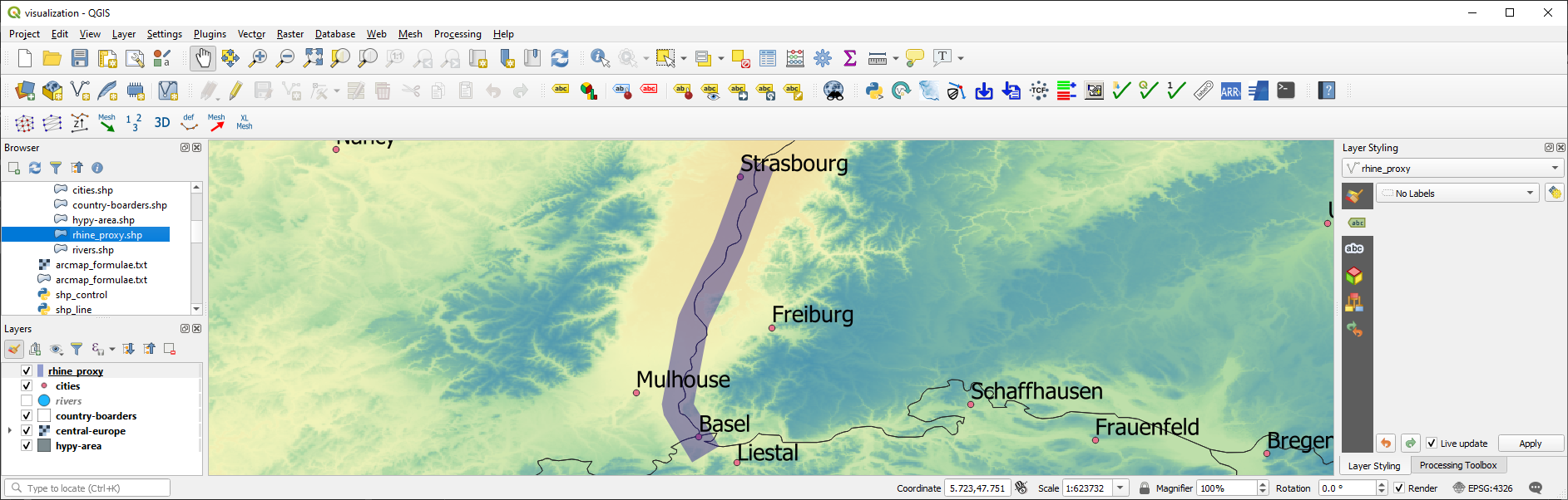
Fig. 48 The line approximating the Rhine river in QGIS.#
Polygon Shapefile#
Polygons are surface patches that can be created point-by-point, line-by-line, or from a "Multipolygon" WKB definition. When creating polygons from points or lines, we want to create a surface and this is why the corresponding geometry type is called wkbLinearRing for building polygons from both points or lines (rather than wkbPoint or wkbLine, respectively). The following code block features an example for building a polygon shapefile delineating the hydraulic laboratory of the University of Stuttgart. The difference between the above example for creating a line shapefile are:
The projection is
EPSG:4326.The point coordinates are generated within an
ogr.wkbLinearRingobject step-by-step rather than in a loop over dictionary entries.File, variable, and field names.
shp_dir = r"" + os.path.abspath("") + "/geodata/shapefiles/va4wasserbau.shp"
va_geo = create_shp(shp_dir, layer_name="basemap", layer_type="polygon")

# create .prj file for the shapefile for GIS map applications
with open(shp_dir.split(".shp")[0] + ".prj", "w+") as prj:
    prj.write(get_wkt(4326))

# get basemap layer
lyr = va_geo.GetLayer()

# create polygon points
pts = ogr.Geometry(ogr.wkbLinearRing)
pts.AddPoint(9.103686, 48.744251)
pts.AddPoint(9.104689, 48.744198)
pts.AddPoint(9.104667, 48.743960)
pts.AddPoint(9.103557, 48.744009)

# create polygon geometry
poly = ogr.Geometry(ogr.wkbPolygon)
# build polygon geometry from points
poly.AddGeometry(pts)

# add field to classify building type
field = ogr.FieldDefn("building", ogr.OFTString)
lyr.CreateField(field)

poly_feature_defn = lyr.GetLayerDefn()
poly_feature = ogr.Feature(poly_feature_defn)
poly_feature.SetGeometry(poly)
poly_feature.SetField("building", "Versuchsanstalt")

lyr.CreateFeature(poly_feature)

lyr = None
va_geo = None
Build Shapefile from JSON#
Loading geometry data from in-line defined variables is cumbersome in practice, where geospatial data are often provided on public platforms (e.g., land use or cover). The following example uses a JSON file generated with map service data from the Baden-Württemberg State Institute for the Environment, Survey and Nature Conservation (LUBW), where polygon nodes are stored in WKB polygon geometry format ("MultiPolygon (((node1_x node1_y, nodej_x, nodej_y, ... ...)))"):
The JSON file (download hq100-dreisam.json and save it to a subdirectory called
/geodata/json/)is read with Pandas and the shapefile is created, as before, with thecreate_shpfunction.The projection is
EPSG:25832.Two fields are added in the form of
"tbg_name"(the original string name of the polygons in the LUBW data), and"area"(a real number field, in which the polygon area is calculated in m2 usingpolygon.GetArea()).
The polygon geometries are derived from the WKB-formatted definitions in the
"wkb_geom"field of the pandas dataframe objectdreisam_inundation.
# get data from json file
dreisam_inundation = pd.read_json(r"" + os.path.abspath("") + "/geodata/json/hq100-dreisam.json")

# create shapefile
shp_dir = r"" + os.path.abspath('') + "/geodata/shapefiles/dreisam_hq100.shp"
dreisam_hq100 = create_shp(shp_dir, layer_name="basemap", layer_type="polygon")

# create .prj file for the shapefile for GIS map applications
with open(shp_dir.split(".shp")[0] + ".prj", "w+") as prj:
    prj.write(get_wkt(25832))

# get basemap layer
lyr = dreisam_hq100.GetLayer()

# add string field "tbg_name"
lyr.CreateField(ogr.FieldDefn("tbg_name", ogr.OFTString))

# add string field "area"
lyr.CreateField(ogr.FieldDefn("area", ogr.OFTReal))

for wkt, tbg in zip(dreisam_inundation["wkt_geom"], dreisam_inundation["TBG_NAME"]):
    # create Feature as child of the layer
    feature = ogr.Feature(lyr.GetLayerDefn())
    # assign tbg_name
    feature.SetField("tbg_name", tbg)
    # use WKT format to add a polygon geometry to the Feature
    polygon = ogr.CreateGeometryFromWkt(wkt)
    # define default value of 0 to the area field
    feature.SetField("area", polygon.GetArea())

    feature.SetGeometry(polygon)
    # append the new feature to the basement layer
    lyr.CreateFeature(feature)

lyr = None
dreisam_hq100 = None
Tip
Open the new dreisam_hq100.shp in QGIS and explore the attribute table.
Also GeoJSON data can be used to create an ogr.Geometry with ogr.createFromGeoJson(FILENAME):
from osgeo import ogr
geojson_data = """{"type":"Point","coordinates":[1013452.282805,6231540.674235]}"""
point = ogr.CreateGeometryFromJson(geojson_data)
print("X=%d, Y=%d (EPSG:3857)" % (point.GetX(), point.GetY()))
X=1013452, Y=6231540 (EPSG:3857)
Calculate Geometric Attributes#
The above code block illustrates the usage of polygon.GetArea() to calculate the polygon area in m\(^2\). The ogr library provides many more functions to calculate geometric attributes of features and here is a summary:
Unify multiple polygons
wkt_... = ...
polygon_a = ogr.CreateGeometryFromWkt(wkt_1)
polygon_b = ogr.CreateGeometryFromWkt(wkt_2)
polygon_union = polygon_a.Union(polygon_b)Intersect two polygons
polygon_intersection = polygon_a.Intersection(polygon_b)Envelope (minimum and maximum extents) of a polygon
env = polygon.GetEnvelope()
print("minX: %d, minY: %d, maxX: %d, maxY: %d" % (env[0],env[2],env[1],env[3])Convex hull (envelope surface) of multiple geometries (points, lines, polygons)
all_polygons = ogr.Geometry(ogr.wkbGeometryCollection)
for feature in POLYGON-SOURCE-LAYER: all_polygons.AddGeometry(feature.GetGeometryRef())
convexhull = all_polygons.ConvexHull()
Saveconvexhullto shapefile (use thecreate_shpfunction as shown in the above examples or read more at pcjerick’s Github pages)
Tip: To create a tight hull (e.g., of a point cloud), look forconcavehullfunctions.Length (of a line)
wkt = "LINESTRING (415128.5 5320979.5, 415128.6 5320974.5, 415129.75 5320974.7)"
line = ogr.CreateGeometryFromWkt(wkt)
print("Length = %d" % line.Length())Area (of a polygon):
polygon.GetArea()(see above example)Example to calculate centroid coordinates of polygons.
Important
The units of the geometric attribute (e.g., m\(^2\), U.S. feet, or others) are calculated based on the definitions in the .prj file <prjp> (recall the definition of projections in WKT format in the Projections and Coordinate Systems section).
Export to Other Formats#
The above examples deal with .shp files only, but other formats can be useful (e.g., to create web applications or export to Google Earth). To this end, the following paragraphs illustrate the creation of GeoJSON and KML files. Several other conversions can be performed, not only between file formats but also between feature types. For instance, polygons can be created from point clouds (among others with the ConvexHull method mentioned above). Interested students can learn more about conversions in Michael Diener’s Python Geospatial Analysis Cookbook.
GeoJSON#
GeoJSON files can be easily created as before, even without activating a driver:
triangle = ogr.Geometry(ogr.wkbLinearRing)
triangle.AddPoint(-11717151.498691, 2356192.894805)
triangle.AddPoint(-11717120.446149, 2355586.175893)
triangle.AddPoint(-11719392.059083, 2354012.050842)

polygon = ogr.Geometry(ogr.wkbPolygon)
polygon.AddGeometry(triangle)

with open(r"" + os.path.abspath('') + "/geodata/geojson/pitillal-triangle.geojson", "w+") as gjson:
    gjson.write(polygon.ExportToJson())
For more robust file handling and defining a projection, activate the driver ogr.GetDriverByName("GeoJSON"). Thus, the creation and manipulation of GeoJSON files work similarly to the shapefile handlers shown above.
gjson_driver = ogr.GetDriverByName("GeoJSON")

# make spatial reference
sr = osr.SpatialReference()
sr.ImportFromEPSG(3857)

# create GeoJSON file
gjson = gjson_driver.CreateDataSource("pitillal-full.geojson")
gjson_lyr = gjson.CreateLayer("pitillal-full.geojson", geom_type=ogr.wkbPolygon, srs=sr)

# get layer feature definitions
feature_def = gjson_lyr.GetLayerDefn()
# create new feature
new_feature = ogr.Feature(feature_def)
# assign the triangle from the above code block
new_feature.SetGeometry(polygon)
# add new feature to Layer
gjson_lyr.CreateFeature(new_feature)

# close links to data sources
gjson = None
gjson_lyr = None
KML (Google Earth)#
To display point, line, or polygon features in Google Earth, features can be plugged into Google’s KML (Keyhole Markup Language), similar to the creation of a GeoJSON file, and with the function geometry.ExportToKML:
triangle = ogr.Geometry(ogr.wkbLinearRing)
triangle.AddPoint(-11717151.498691, 2356192.894805)
triangle.AddPoint(-11717120.446149, 2355586.175893)
triangle.AddPoint(-11719392.059083, 2354012.050842)

polygon = ogr.Geometry(ogr.wkbPolygon)
polygon.AddGeometry(triangle)

#geojson = poly.ExportToJson()
with open(r"" + os.path.abspath("") + "/geodata/pitillal-triangle.kml", "w+") as gjson:
    gjson.write(polygon.ExportToKML())
Moreover, similar to GeoJSON files and shapefiles, KML files can be generated more robustly (with a defined projection, for example). All you need to do is initiating the KML driver (kml_driver = ogr.GetDriverByName("KML")) and define a KML data source (kml_file = kml_driver.CreateDataSource(FILENAME.KML)).
Exercise
Familiarize with shapefile handling in the geospatial ecohydraulics exercise.